


Next: LWS Measurements of Saturn's Up: ISO Info no. 10 Previous: ISOPHOT Science highlights
ISO Observations of the Hubble Deep Field
During December 1995 the Hubble Space Telescope scanned 5 square arcminutes of
the sky 150 times to make the deepest image of the sky ever achieved at four
ultraviolet, visible and near infrared wavelengths (0.3-0.9 ![]() m). The
images of what has become known as the Hubble Deep Field were released to the
scientific community in January 1996.
m). The
images of what has become known as the Hubble Deep Field were released to the
scientific community in January 1996.
The ISO Project Scientist, Martin Kessler, decided to issue a call for
proposals for ISO observations of the Hubble Deep Field. The proposal
submitted from Imperial College in consortium with other European institutes
to carry out a survey of the Hubble Deep Field with ISOCAM at its most
sensitive wavelengths, 6.7 and 15 ![]() m 's, was selected. Observations were
carried out in July.
m 's, was selected. Observations were
carried out in July.
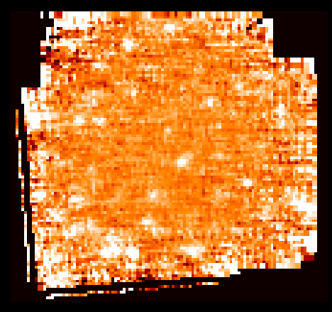
The data from this survey have now been analyzed. The maps at both 6.7 and 15
![]() m 's show several sources of infrared radiation, which can be associated with
optical galaxies in the Hubble maps. The ISO -HDF image shown on the cover is
15
m 's show several sources of infrared radiation, which can be associated with
optical galaxies in the Hubble maps. The ISO -HDF image shown on the cover is
15 ![]() m map of the Hubble Deep Field area with the white spots being the
detected infrared sources.
m map of the Hubble Deep Field area with the white spots being the
detected infrared sources.
Of the fourteen best cases, for four we are probably just seeing infrared radiation from red giant stars in the galaxies (i.e. we are seeing normal galaxies). For the other ten, the infrared radiation is interpreted as emission from a dust shrouded `starburst', a tremendous burst of star formation. The rates at which stars are being formed are estimated to be from 10-2000 solar masses per year, compared with the current star formation rate in our Galaxy of 1 solar mass per year. At these rates of star formation, the entire mass of stars in a typical galaxy could be made in about 1 billion years. The consortium believe they are seeing the main episode of star formation in these galaxies, during which most of the heavy elements in a galaxy are being manufactured.
The home page for ISO observations of the HDF is at
http://athena.ph.ic.ac.uk/elais/hdf/. The ISO -HDF data was released to the
community on 2 December 1996, via the above web page, and comprised:
Standard ESA data products: Edited Raw Data (ERDs); Standard Processed
Data (SPDs); Auto Analysis Results (AARs), etc.
Data maps: 7 and 15 ![]() m maps
Noise maps: for both 7 and 15
m maps
Noise maps: for both 7 and 15 ![]() m wavebands.
Coverage maps: for both 7 and 15
m wavebands.
Coverage maps: for both 7 and 15 ![]() m wavebands.
Source lists: for each waveband there is a complete sample and a
supplementary sample.
Preprints: these describe the methods used to reduce
the ISO -HDF data and extract sources from the resultant maps, plus the
first set of scientific results from the analysis of the ISO -HDF data.
m wavebands.
Source lists: for each waveband there is a complete sample and a
supplementary sample.
Preprints: these describe the methods used to reduce
the ISO -HDF data and extract sources from the resultant maps, plus the
first set of scientific results from the analysis of the ISO -HDF data.
Next: LWS Measurements of Saturn's Up: ISO Info no. 10 Previous: ISOPHOT Science highlights
Tue Jan 7 17:47:45 MET 1997